

More on the MJO
Image Courtesy of NOAA
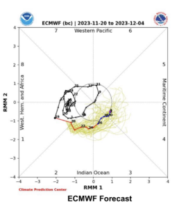
The image here shows the NOAA forecast progression of the MJO from 20th of November to the 4th of December in Red and Blue. The progression is East firstly over the Indian Ocean then the Maritime Continent, Australia.
It shows, historically, a rotation in the Western Hemisphere and Africa before releasing and rapidly transiting the Indian Ocean and Australia in early November. Note the location from the 7th to 15th of November over the Western Pacific, about the time TC Mal formed and clobbered Vanuatu on the 15th of November.
The inner ring on the chart indicates a benign MJO, anything outside the ring, the red line (Active) in the forecast period over the Indian Ocean changes to Blue (Benign) as it enters the inner ring, 26th to 27th November over Australia.
Currently crossing the Australian Continent would suggest the next event will reach the SW Pacific shortly! Cyclogenisis accelerates as the summer in the Southern Hemisphere warms sea water surface temperatures, adding the MJO adds to this, watch out for active conditions mid to late December. Click HERE for more info…
The MJO explained.
There are a number of weather phenomena that affect South Pacific Weather, the Madden Julian Oscillation is one!
It’s named after its discoverers, meteorologists Roland Madden and Paul Julian.
Imagine the MJO as a traveling pulse or wave in the atmosphere that moves eastward along the equator, primarily in the Indian and Pacific Ocean regions. It’s like a big circle of stormy weather that travels around the globe.
The MJO influences weather patterns by causing changes in cloud cover, rainfall, and winds in the tropics. When the MJO is passing over a certain area, it can lead to periods of increased rainfall and thunderstorms. On the other hand, when it moves away, drier and more stable conditions may prevail.
It’s essential to understand the MJO because it can impact weather and climate on a global scale. For example, it can affect the frequency of tropical cyclones, monsoons, and even the behaviour of the El Niño and La Niña phenomena.
Overall, the MJO is an important piece of the puzzle in understanding and predicting weather patterns, especially in tropical regions around the world.
In the southwest Pacific, the MJO occurs multiple times throughout the year. It doesn’t have a strict schedule, but it generally cycles every 30 to 60 days. It’s not a constant weather feature, and its impact can vary.
For cruising sailors in the southwest Pacific, the MJO can significantly affect sailing conditions. Here’s how:
- Weather Changes: The MJO can bring about shifts in weather patterns in the region. When the MJO is passing over an area, it often brings increased cloud cover, heavy rainfall, and stronger winds. This can lead to rough and stormy conditions, making sailing challenging and potentially dangerous. Cruisers need to be vigilant and prepared for sudden changes in weather when the MJO is active.
- Tropical Cyclones: The MJO can influence the development and behavior of tropical cyclones (hurricanes or typhoons). During active MJO phases, the likelihood of tropical cyclone formation can increase. Cruising sailors need to closely monitor weather forecasts and be aware of potential cyclone threats during these periods. It may be necessary to seek safe harbors or alter course to avoid dangerous conditions.
- Rainfall and Visibility: The MJO can bring heavy rainfall, reducing visibility and making navigation more challenging. Limited visibility can be a safety concern, especially in busy shipping lanes or near coastal areas with reefs and shallow waters.
- Sea State: The increased winds associated with the MJO can lead to higher waves and rough seas. For sailors, this means being prepared for rough passages and potentially uncomfortable sailing conditions.
- Plan voyages with MJO forecasts in mind and remain flexible in your sailing itinerary. Being ready to adjust routes, seek shelter, or wait for more favorable weather conditions can make the difference between a smooth sailing experience and encountering dangerous situations.
- if in doubt engage a weather router to advise you on the safest time to depart and the route to be taken for the safest passage.
To access the current MJO forecast, visit http://www.bom.gov.au/climate/mjo/