
Mi Weather – Mediterranean, Atlantic and Caribbean – Billy Sesack
What Is El Niño?
El Niño is the warm phase of the El Niño–Southern Oscillation, commonly called ENSO. It begins in the tropical Pacific Ocean when the normal easterly trade winds weaken. This allows unusually warm surface water to spread eastward toward Central and South America while reducing the normal upwelling of cold water along the South American coast.
Although El Niño begins in the Pacific, the warmer water changes where large areas of air rise, sink, and produce thunderstorms. This disrupts the Walker circulation and changes
1
the position and strength of major jet streams. These changes spread through the atmosphere and influence weather patterns far beyond the Pacific.
El Niño events occur approximately every two to seven years. They normally last between nine and twelve months, although some continue longer, and usually reach their greatest strength during the Northern Hemisphere winter (National Oceanic and Atmospheric Administration [NOAA], 2026b).
It is important to understand that El Niño changes the probability of certain weather conditions. It does not guarantee that every El Niño year will produce the same weather. Atlantic water temperatures, the North Atlantic Oscillation, the position of the Azores-Bermuda High, and other climate patterns can strengthen or weaken its effects.
The Western Atlantic During Summer
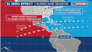
The most recognized summer effect of El Niño in the western Atlantic is a general reduction in tropical cyclone activity. Thunderstorms over the warmer Pacific send stronger upper-level winds eastward across the Caribbean and tropical Atlantic. These winds increase vertical wind shear, meaning that the wind changes speed or direction with height.
A developing tropical cyclone needs its thunderstorms to remain vertically organized above its low-pressure center. Strong wind shear tilts the storm and separates its thunderstorms from its circulation. This makes it harder for tropical waves and depressions to develop into organized hurricanes. El Niño can also make the atmosphere over the tropical Atlantic more stable, further limiting thunderstorm development (NOAA, 2026a).
The suppressing effect normally becomes most noticeable during the later part of hurricane season, particularly from August through October. This often results in fewer Atlantic hurricanes and fewer long-lived Cape Verde storms reaching the western Atlantic, Bahamas, or East Coast.
However, El Niño does not eliminate hurricane risk. A storm can still develop close to the United States, Bahamas, or Gulf Coast where wind shear is temporarily weaker. An unusually warm Atlantic can also partially counteract El Niño by providing additional heat
2
and moisture for tropical systems. Therefore, a predicted El Niño should never be treated as a reason to ignore hurricane planning.
Outside the tropics, El Niño’s influence on summer weather over the eastern United States and western Atlantic is relatively weak. The Bermuda High, Atlantic sea-surface temperatures, fronts, and short-term weather patterns usually have more control over the daily wind and rainfall (Barnston, 2015).
For mariners, the practical result is that an El Niño summer may produce fewer organized tropical cyclones, but it does not necessarily mean consistently calm weather. Squall lines, tropical waves, local thunderstorms, and isolated hurricanes remain possible.
The Western Atlantic During Winter
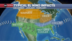
El Niño normally has a stronger and more dependable effect on the western Atlantic during winter. The Pacific jet stream tends to move farther south and extend eastward across Mexico, the Gulf Coast, Florida, and the western Atlantic.
3
This southern storm track usually brings wetter and stormier conditions to the southern United States. Low-pressure systems can develop over the Gulf of Mexico, cross Florida, and strengthen after reaching the warm waters of the Gulf Stream. These systems may produce heavy rain, thunderstorms, strong frontal passages, and rough seas from the Gulf Coast through Florida, the Bahamas, and the waters offthe southeastern United States (NOAA, 2026b).
For vessels traveling between the United States, Bahamas, and Caribbean, an El Niño winter can mean more frequent changes between southerly winds ahead of a front and strong northwesterly or northeasterly winds behind it. When these winds oppose the Gulf Stream, sea conditions can become steep and dangerous very quickly.
Farther north, the exact effect on winter storms is less dependable. El Niño can influence the position of the North Atlantic storm track, but the North Atlantic Oscillation and other circulation patterns may determine whether storms move offshore, track toward New England, or remain farther south.
4
References
ABC News. (2026, August 13). Typical El Niño impact [Map]. https://abcnews.com/US/potentially-historic-el-nino-takes-shape-reaching-us/story?id=135615867
AOML Communications. (2026, June 2). How does El Niño impact Atlantic hurricane season? NOAA Atlantic Oceanographic and Meteorological Laboratory. https://www.aoml.noaa.gov/how-does-el-nino-impact-atlantic-hurricane-season/
Barnston, A. (2015, May 28). With El Niño likely, what climate impacts are favored for this summer? NOAA Climate.gov. https://www.climate.gov/news-features/blogs/enso/el-ni%C3%B1o-likely-what-climate-impacts-are-favored-summer
FOX Weather. (2026, April 9). Impact of El Niño on Atlantic hurricane season [Infographic]. https://www.foxweather.com/weather-news/2026-hurricane-season-colorado-state-university-forecast-el-nino
National Environmental Satellite, Data, and Information Service. (2017, December 16). El Niño [Satellite image]. National Oceanic and Atmospheric Administration. https://www.nesdis.noaa.gov/news/el-nino
National Oceanic and Atmospheric Administration. (2026, September 23). What are El Niño and La Niña? National Ocean Service. https://oceanservice.noaa.gov/facts/ninonina.html
5