
Avoiding Weather is always the plan but is particularly important when you’re planning a passage in the fringe periods or out of season. An example of this would be the South Pacific Cyclone Season which runs from November to April, the southern summer.
Ocean Passages don’t have to include a spell when you wish you weren’t there! It’s like a recipe but with only a few very important ingredients, Patience and Information plus a knowledge on how to best use the information, add to this a weather router as a fourth ingredient, particularly for out of season, longer passages and the Passage to New Zealand that takes you south into the migrating weather patterns where positioning the boat correctly can have a huge impact if you get it wrong!
Let’s start with the first Ingredient, Patience…..
I’ve seen more vessels damaged on passages started at the wrong time while cruising than any other reason. Departure Planning is essential. If you’re intending to take crew let them know from the start that it’s your timing you’ll be working too, not their schedule or flight times. Flexibility is the key, we’re cruising not racing after all.
As to the information, there is now a host of information available, much you can get on passage with the right tools and more that is available from internet sources. Local knowledge and a good grasp of how weather works is also import
Good departure planning is essential and makes up a considerable portion of the work for a good Weather Router. Getting this right can be the difference between a great passage and a disaster. Once you’ve decided to leave, the next trick is to always put the boat in the right place to take best advantage of the weather that’s coming, Passage Management.
The trick with Passage Management is to always be one step ahead of the weather. There’s a huge volume of information available to help with this but not all of it is easy to get while on passage, well perhaps not if you have very deep pockets:-) This is where a weather router comes in.
Let’s first take a look at what is available Information Wise and how to get it.
For the average cruiser who wants to keep the costs down, the easiest and most affordably way to get information on a passage is via an Iridium Go. PredictWind have a very good deal on these units and offer a very competitive air time package, mix this with a Standard or Professional PredictWind subscription and their Offshore App and you’ve got your information side of the recipe well underway. Understanding what you’re seeing is another mater and I’ll give you some links at the end to some resources that will help, the first of which is a huge resource of videos on the PredictWind website.
If you’re competent at weather analysis the above is likely all you’ll need, make sure you go for the Iridium “Unlimited” Package to avoid bill shock and give you the tools to download the weather twice a day. There’s a tendency to skimp on the area you’re downloading and the length of time you’re looking forward, don’t! Your ability to look at what’s coming, say 5 days out and downloading it twice a day will enable you to see the trends and if the forecast is changing between downloads.
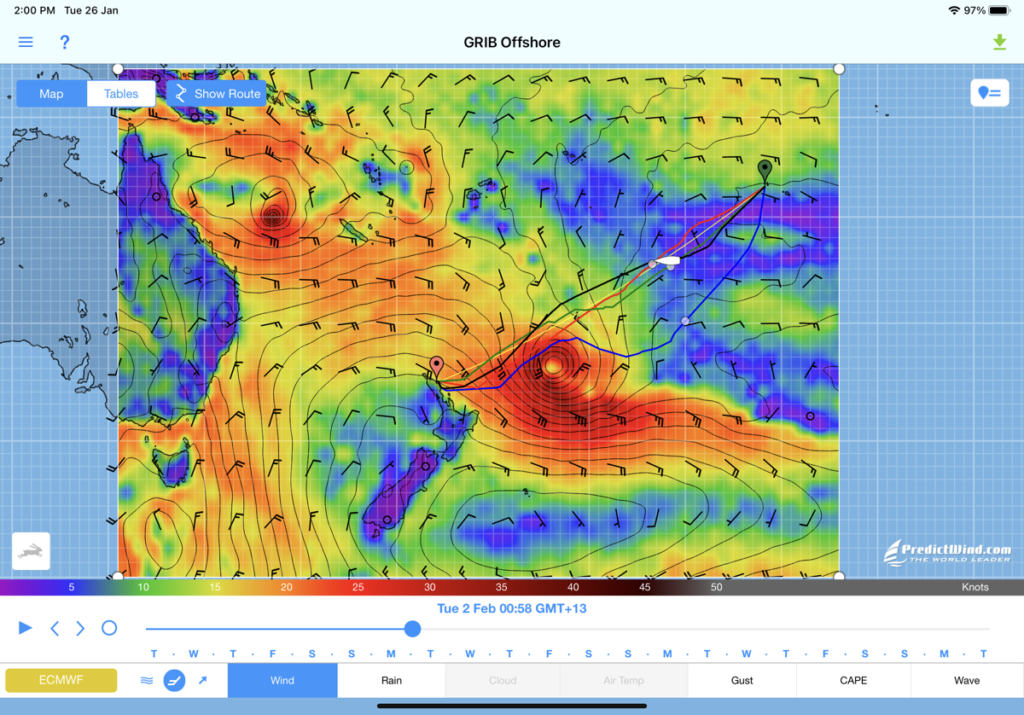
To give you an example of this on a passage to Tonga (before Covid) two boats were heading for Minerva Reef. Boat one was downloading the weather as above and notices the High pressure system was moving off quicker than expected* and the easterly winds they were currently enjoying would soon back to the NE then N which would put them on the wind. Time to put some easting “In the bank”, that’s a racing term and simply means if you can head a little above the course to the mark then do so in case you get a knock. So boat one takes a right turn and for two days put some easting in. When the winds backed they bore away and were able to make Minerva without tacking and were anchored before the front that always comes as the high moves off to the east. Boat two however is not quite so savvy and ends up taking many tacks to reach its goal just as boat one is ready to leave on the Southerly winds on the next system. Boat one’s partner has been snorkelling and having fun, boat two’s, well she’s not happy!
This same method can be used to avoid heavy weather, low pressure systems or active cells embedded in a trough line. In other words we’re positioning the boat in the right place for best advantage. Seeing exactly where the Active Cells are can be seen on IR (Infra Red) Satellite imagery.
Routing boats on the cusp of the seasons becomes more problematic and even experienced cruisers use a router for weather assistance, using a multitude of tools to “thread the needle”. An example of this was clearly shown in recent routings from French Polynesia to New Zealand. The length of this passage means while you can get a good departure window for perhaps the first 6-8 days, with a passage of up to 20 days for some boats, contingencies need to be in place to handle whatever comes after that. Especially important as these passages where in early January, well into the cyclone season.
One of the really cool services PredictWind offers is GPS Tracking. This is becoming more important in the current times with Covid and the need to prove an uninterrupted track. It’s also a gem for your weather router, any time day or night we can see exactly where you are and the weather you’ve got. The lat Lon can be then transferred to the PredictWind routing software, easy:-) If there’s a group and this can be simply friends cruising together, a rally or the boats I’m routing, you can create a page with all of them on it.
On the Offshore App I’d recommend alway tick the box for the GMDSS forecast. This is a text format analysis of fronts and specific weather events in or near your location.
For routing in the fringes or during the early and late stages of the Cyclone or Hurricane seasons your router is also going to be looking at sources that analyse what’s now referred to as Cyclo-genisis. This is the early warning of these storms based on what conditions we know form them. In layman’s terms any type of low pressure system in the tropics is formed by convection, warm to very warm water creates convection, the rotation of the earth or the Coriolis effect creates rotation and a low is born. In many cases these can be forecast up to a week prior to their formation giving lots of advance notice to enable the vessel to be in the right place as the low passes, not in its path. Not all lows develop into Cyclones but most times it’s worth avoiding them. In the example below (Play the Progression video) with 5 days advance notice in the PredictWind forecasting and as we got closer the IR Satellite images, we were able to route the three vessels not only south of the main rotation, this was one of three lows embedded in a trough line that ran all the way north to the SPCZ** but also several active cells embedded in the trough
***You may notice, we are using Infra Red Satellite Imagery, the darker the red, the more active the cell, the more we need to avoid it. for a full explanation of IR v Visual light.
On a regular basis we’re also checking other forecast sources like Fiji Met and the Joint Typhoon Warning Centre – JTWC in Hawaii for their forecasts and warnings.
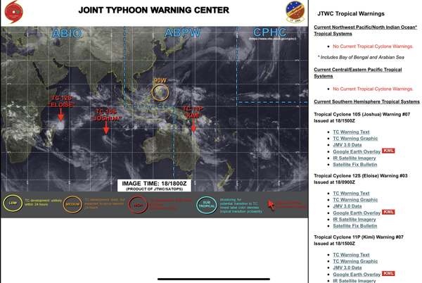
You’ll note there is a new event of the North Queensland Coast of Australia, Cyclone Kimi, the image on the right shows it projected track. Plus an unusual event, a possible Typhoon Genisis out of season in the Northern Hemisphere.
Using both of these sources we were able to complete the passage with forecasts predictions of <5% likelihood of Cyclo-genisis.
All three vessels are now safely in New Zealand with four days separating the first from the last.
In the southern hemisphere the weather systems migrate west to east in a constant high follows low follows high progression. For a full analysis of this click the link ….
https://coastalandoffshorecruising.com/weather/south-pacific-weather/ For Passage Planning
https://coastalandoffshorecruising.com/weather/understanding-south-pacific-weather/
Or check out the Yachtsman’s South Pacific- Crossing Planner app from Sail South Pacific on the App Store. for in depth South Pacific Weather information.
** SPCZ – South Pacific Convergence Zone https://coastalandoffshorecruising.com/weather/south-pacific-convergence-zone/
***What is an IR satellite image?
IR or infrared satellite imagery is, in simple terms, a temperature map. The weather satellite detects heat energy in the infrared spectrum (infrared energy is invisible to the human eye). The satellite image displays objects (whether clouds, water or land surfaces) based on the temperature of the object. Warm temperatures appear in dark shades. Cold temperatures appear in light shades. A temperature scale(in degrees Celsius) is depicted to the left of the image.
The chief advantage of IR imagery is that it’s not dependent on sunlight. Visible imagery(like the photos you take with a normal camera) relies on sufficient sunlight reflecting off a surface to be viewable. It’s useless at night, but IR imagery relies on emitted heat energy(detectable day or night if you have the right equipment).
You can infer relative altitudes of clouds from their temperature. Since temperature, in general, decreases with increasing height, high altitude clouds will appear whiter than low altitude clouds.
Visible vs. IR — Why?
A visible satellite image is created by looking only at the visible portion of the light spectrum and is thus only really useful during daylight hours. The Infrared (IR) image comes from the satellite detecting heat energy in the infrared sepectrum and thus does not depend on visible light. For this reason we switch between the visible and IR images at 1500 GMT (8:00am PDT) and 0200 GMT (7:00pm PDT).
**** https://www.eldoradoweather.com/satellite/ssec/spacific-color-ir-sat.html
* Cyclone Kimi, note the very dark red patch.

An example of a GMDSS Forecast
WTPS31 PGTW 182100
MSGID/GENADMIN/JOINT TYPHOON WRNCEN PEARL HARBOR HI//
SUBJ/TROPICAL CYCLONE 11P (KIMI) WARNING NR 008//
RMKS/
- TROPICAL CYCLONE 11P (KIMI) WARNING NR 008
01 ACTIVE TROPICAL CYCLONE IN SOUTHPAC
MAX SUSTAINED WINDS BASED ON ONE-MINUTE AVERAGE
WIND RADII VALID OVER OPEN WATER ONLY
—
WARNING POSITION:
181800Z — NEAR 17.7S 147.4E
MOVEMENT PAST SIX HOURS – 315 DEGREES AT 01 KTS
POSITION ACCURATE TO WITHIN 025 NM
POSITION BASED ON CENTER LOCATED BY A COMBINATION OF
SATELLITE, RADAR AND SYNOPTIC DATA
PRESENT WIND DISTRIBUTION:
MAX SUSTAINED WINDS – 035 KT, GUSTS 045 KT
WIND RADII VALID OVER OPEN WATER ONLY
DISSIPATING AS A SIGNIFICANT TROPICAL CYCLONE OVER WATER
RADIUS OF 034 KT WINDS – 070 NM NORTHEAST QUADRANT
055 NM SOUTHEAST QUADRANT
040 NM SOUTHWEST QUADRANT
045 NM NORTHWEST QUADRANT
REPEAT POSIT: 17.7S 147.4E
—
FORECASTS:
12 HRS, VALID AT:
190600Z — 17.8S 147.3E
MAX SUSTAINED WINDS – 030 KT, GUSTS 040 KT
WIND RADII VALID OVER OPEN WATER ONLY
DISSIPATED AS A SIGNIFICANT TROPICAL CYCLONE OVER WATER
—
REMARKS:
182100Z POSITION NEAR 17.7S 147.4E.
18JAN21. TROPICAL CYCLONE 11P (KIMI), LOCATED APPROXIMATELY 103
NM EAST-SOUTHEAST OF CAIRNS, AUSTRALIA, HAS TRACKED NORTHWESTWARD
AT 01 KNOT OVER THE PAST SIX HOURS. ANIMATED ENHANCED INFRARED (EIR)
SATELLITE IMAGERY SHOWS THE SYSTEM CONTINUING TO UNRAVEL AS THE
ASSOCIATED CONVECTION HAS SHEARED FURTHER SOUTHEASTWARD FROM THE
RAGGED LOW LEVEL CIRCULATION (LLC) THAT HAS BECOME QUASI-STATIONARY.
THE INITIAL POSITION IS PLACED WITH FAIR CONFIDENCE BASED ON THE EIR
ANIMATION, COMPOSITE RADAR LOOPS, AND TRIANGULATION FROM NEARBY
SURFACE OBSERVATIONS. THE INITIAL INTENSITY OF 35KTS IS BASED ON AN
OVERALL ASSESSMENT OF AGENCY DVORAK ESTIMATES AND TRENDS ANALYSIS OF
PGTW T2.5/3.0 (DATA T OF 1.5) AND ABOM T2.0/2.5, AND EXTRAPOLATION
FROM NEARBY SURFACE WIND OBSERVATIONS. ANALYSIS INDICATES THE SYSTEM
IS UNDER RELATIVE VERTICAL WIND SHEAR OF 25KT+ WITH UPPER LEVEL
WINDS DIAMETRICALLY AGAINST THE LOW LEVEL SOUTHERLY WINDS, RESULTING
IN A DECOUPLING OF THE LLC. ALTHOUGH THERE IS MODERATE POLEWARD
UPPER LEVEL OUTFLOW AND WARM SST (29C), THE SYSTEM IS NOT EXPECTED
TO RE-CONSOLIDATE, LEADING TO DISSIPATION BY TAU 12. THE REMNANTS OF
TC 11P WILL LIKELY DRIFT NORTHWARD WITH THE LOW LEVEL WIND FLOW.
THIS IS THE FINAL WARNING ON THIS SYSTEM BY THE JOINT TYPHOON WRNCEN
PEARL HARBOR HI. THE SYSTEM WILL BE CLOSELY MONITORED FOR SIGNS OF
REGENERATION. MAXIMUM SIGNIFICANT WAVE HEIGHT AT 181800Z IS 12
FEET.//
NNNN